|
|
|
|
Welcome to Petroleum Geology Forums
This is a free online community that aims to bring petroleum professionals and geologists together and share valuable knowledge. Registration is easy so become a member now for instant free access.
- Petroleum Geologists can stay up to date with industry related topics and exchange ideas and concepts.
- Upstream Oil and Gas Consultants get a chance to share their expertise and gain exposure to land future projects.
- Geology students and graduates can join the discussion and get into contact with potential future employees.
|
|
|
Fluvial Sequence Stratigraphy
W.J. van Strien
For contact information use EPGeology.com contact form.
|
Introduction
Sequence stratigraphy was developed in the late 1970’s and synthesized in the AAPG memoir 26 (Payton, 1977). Initially the concept was designed to cope with the shallow marine to deltaic interval of the sedimentary system, but has since been expanded into the deeper marine realm and into fluvial to alluvial settings. Whatever the setting, sequence stratigraphy provides a useful toolbox for stratigraphic analysis, the identification of timelines, prediction of facies distribution and necessitates thinking about the allogenic forces acting on the basin. Sequence stratigraphy relies on the recognition of genetically related strata (eg. deposited during a specific interplay between the rate of accommodation creation or destruction and the rate of sedimentation) bounded by unconformities or their correlative conformities. Although unconformable surfaces may be time diachronous, they can usually be related to a single “event” in geological time, if this event is related to a mayor allogenic force, then the identification of such a surface will be key to successful correlation.
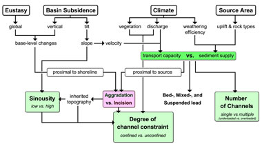
Fig. 1 Allogenic controls on fluvial sedimentation and morphology. Important to note is that fluvial aggradation or incision can be influenced by both downstream and upstream controls. ‘Proximal to shoreline’ refers to mostly sea-level change and basin subsidence. ‘Proximal to source’ refers to mainly climate, source area and basin subsidence. These four main allogenic forces are related to the three key parameters of fluvial morphology: sinuosity, degree of channel constraint and number of channels. After Catuneanu (2007).
As becomes apparent from Fig. 1 there are a four mayor allogenic forces acting on the fluvial system. Because of multiple forces influencing deposition and erosion, the term relative base-level as is commonly used in marginal marine sequence stratigraphy is replaced by the principles of accommodation and sedimentation |
|
Accommodation is the vertical space available for sediment to be deposited and sedimentation refers to this vertical filling of the accommodation space. If this occurs fluvial aggradation takes place; if accommodation is negative, generally, erosion/incision takes place. The slope of fluvial graded profile, the surface of equilibrium between erosion and deposition (Cross, 1991), is mainly controlled by climate and source area as these are the main controls on transport capacity and sediment supply. The graded profile, or equilibrium profile, will always be achieved by a river given enough time and needs to be appreciated on different temporal and spatial scales. For instance, as depicted in FIGURE 1, tilt of the basin may cause a steeper slope over which a river flows, ultimately increasing its flow velocity and its capacity to transport sediment. This will initially lead to erosion of upstream reaches, which will in turn lead to higher sediment load in the downstream reaches. Deposition thus occurs downstream and propagates upstream effectively reestablishing the initial fluvial graded profile that was in place prior to tectonic tilt. A sudden tilt will thus only brusquely affect the rivers flow style while maintaining the same graded profile when observed over longer times. Alternatively, a relative sea-level drop lowers the absolute base-level to which the river grades and will cause erosion to commence near the shoreface and propagate upstream. It largely depends on the length and magnitude of the sea-level drop (Heijst and Postma, 2001) whether or not the new graded profile is achieved, prior to the following sea-level rise. Thus, the speed of migration of the point between erosion and deposition, the knickpoint, depends on erodability of the substrate and the magnitude of the change in graded profile. Small fluvial systems may thus be able to reach equilibrium faster and will record smaller allogenic perturbations, while larger systems effectively buffer small changes in the forces acting on them and will thus only record large changes over longer times.
The knickpoint migrates either upstream or downstream depending on the allogenic force causing the change in the graded profile. Downstream (“proximal to shoreline” in Fig. 1) controls, like eustatic sea-level and vertical basin subsidence effect absolute base-level and cause knickpoint migration upstream while changes in the source areas, climate, tectonic activity and rock type (“proximal to source” in Fig. 1) will induce knickpoint migration downstream. The knickpoint thus always propagates away from the perturbation and the effect of the perturbation reduces with distance from it. In fluvial systems this thus has large implication for aggradation and incision.
|
 |
|
|
In most sequence stratigraphic models base-level lowering is always linked to fluvial incision and the formation of valleys. Although incision is likely, it largely depends on the distance from the shoreline and the length and magnitude of the base-level lowering, whether or not incision will occur noticeably. Also, if base-level change occurs simultaneously with changes in the allogenic forces acting on the source area (like climate changes) these may alter the graded profile even to a point where a base-level fall may coincide with fluvial aggradation. Interaction between eustatic sea-level and climate has been suggested in multiple studies (Catuneanu, 2007; Leeder et al., 1998; Schlager, 1993). The likelihood of this interaction becoming important depends on the distance from the shoreline though.
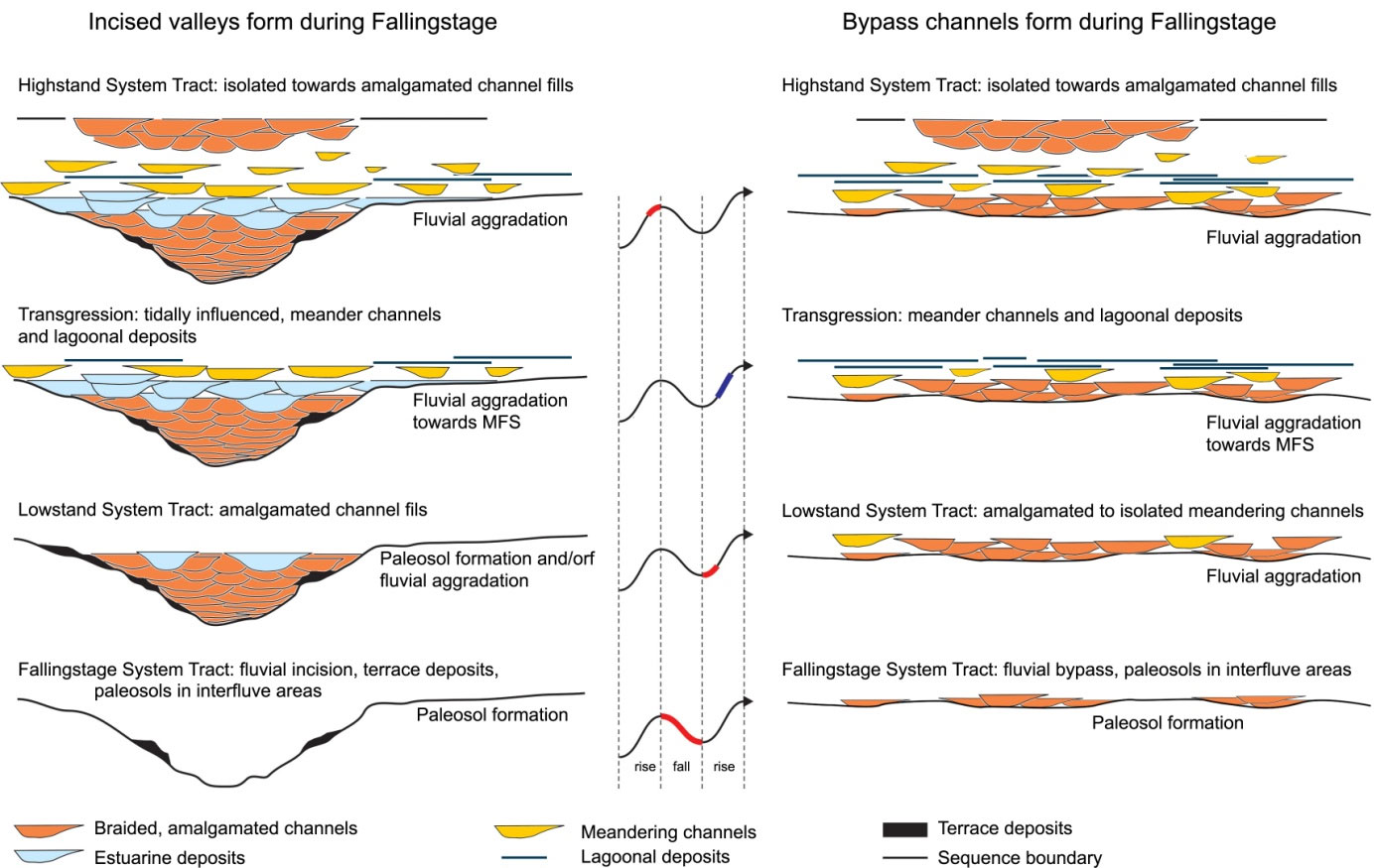
The concept of knickpoint migration thus has important implications for the creation of incised valleys. Incised valleys are favorable hydrocarbon traps and reservoirs as they provide two way closure and usually are filled by good reservoir sands deposited during lowstand backfill. Understanding their formation is thus of prime importance for investigating the hydrocarbon potential of fluvial successions. There is however another common misconception in the formation of incised valleys and their connection to sea-level fall. Incised valleys only occur when the marine slope is steeper than that of the fluvial graded profile during sea-level fall. When there is no, or hardly any, shelf break slope incision will be minimal and rivers will not become confined to a single valley. The effect of knickpoint migration and a bypass fluvial system is depicted in Fig. 2.

Fig. 2 Incised and unincised (bypass) fluvial systems formed during base-level fall and the location of the knickpoint (K) during subsequent stages. A - the highstand shoreline has only slightly prograded over a shallow shelf and the subsequent base-level fall exposes a shelf of which the slope is less steep as that of the fluvial equilibrium profile; a bypass channel develops. B - the base-level falls below the shelf edge and an incised valley develops at the shoreline; the knickpoint (K) moves upstream. C - the base-level has fallen even lower and the knickpoint has traversed the entire coastal plain; an incised (connected) valley has developed. Modified after Posamentier (2001).
|
|
Because bypass channels or incised valleys constrain flow, interfluves develop during falling stages and lowstands. Interfluves are areas of non deposition, palaeosol formation or may be influenced by eolian processes in arid environments. Identification of these horizons is often of prime importance in successfully fluvial sequence stratigraphy, primarily when using well-logs which more often than not fail to penetrate valley successions or bypass channel deposits (considering valleys cannot be targeted due to lack of quality seismic data).
Apart from affecting aggradation and incision the four main allogenic forces also have impact on the three main parameters of fluvial morphology: sinuosity, degree of channel constraint and number of channels. So, even though fluvial incision may not develop observable valleys that confine flow, investigation of fluvial morphology will allow sequence stratigraphy to be conducted. In general the three parameters are grouped into two main fluvial styles; meandering or braided systems, but between the two there are many forms and combinations possible. It is therefore important to understand the allogenic forces controlling fluvial morphology, but it is beyond the scope of this essay to go into depth on this subject. Several authors provide detailed descriptions of fluvial sequence stratigraphy, morphology and their controls (Catuneanu, 2007; Miall, 2000; Posamentier, 2001; Schumm, 1993; Shanley and McCabe, 1993).
In basins where there was minor tectonic activity and largely gradual subsidence it is most likely that either eustatic sea-level and/or climate have controlled fluvial deposition. So fluvial styles have either been dominated by controls proximal to the shoreline or to the source area (see Fig. 1). Hampson et al. (2005) note that fluvial systems up to ~80km from the coastline may still record base-level fluctuations.
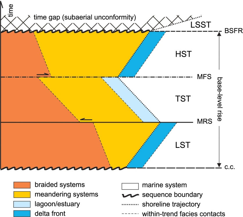
Fig. 2 Fluvial response to downstream base-level rise. Each system tract contains a fining upward succession caused by the continuous coastal aggradation and subsequent shallowing of the fluvial graded profile (See text for further detail). List of abbreviations: Falling Stage System Tract (FSST), Basal Surface of Forced Regression (BSFR), Highstand System Tract (HST), Maximum Flooding Surface (MFS), Transgressive System Tract (TST), Maximum Regressive Surface (MRS), Lowstand System Tract (LST) and correlative conformity (c.c.). From Catuneanu (2007).
|
|
|
|
A simplified basic fluvial sequence stratigraphic model is shown in Fig. 3. Here the spatial and temporal relation between braided and meandering river systems is illustrated for a single base-level cycle. Braided systems develop close to the source area where the slope is generally steeper, sediment coarser, channels are overloaded and accommodation is low. Towards the coastal plain as the fluvial slope becomes flatter, meandering systems take over. Rivers here carry less sediment, are underloaded and therefore usually have single channels. As their sinuosity increases the stresses on the banks raise the probability of bank undermining, and out-of-channel flow, and overbank escape of sediments. This meandering system eventually grades into the estuary or delta front systems. Also, due to the overall rise and flattening of the fluvial gradients the entire cycle has a fining upward tendency. But, due to the interaction between sediment supply and the rate of accommodation creation at the shoreline the entire system progrades or retrogrades during the three stages of base-level rise. Furthermore, two sudden facies shifts may be present during the base-level rise cycle.
At the beginning of the Lowstand System Tract (LST), or Lowstand Normal Regression, following Catuneanu et al. (2009) the coastal plain slope has been graded down to the lowstand level and is therefore steeper than normal. The majority of the system comprises of highly amalgamated braided rivers typical for such a low accommodation setting. If incised valleys have formed they may confine all flow from the catchment area, have high transport capacities and contain coarse clastics which are deposited as the fluvial gradient is raised. They also may have inherited highstand river morphologies complicating sequence stratigraphic analysis based on seismic timeslices. As the rate of base-level increases accommodation is created which is quickly filled resulting in a less steep slope, subsequently rivers slow down and start carrying less bedload and more suspended load, which is deposited on floodplains and levees. Meandering systems develop and start extending both basinwards over the delta front and landwards over the braided system. Then, once the rate of base-level increase becomes so high that sedimentation at the shoreline cannot keep up with the creation of new accommodation space the shoreline transgresses and the entire system shifts landwards. During this Transgressive System Tract (TST) meander systems are drowned and replaced by estuaries or lagoons depending on the presence of incised valleys and dominance of tidal and wave energy. The formation of an estuary or flooding of a shelf to form a lagoon can be quite abrupt (Kerr et al., 1999) and it may occur that a sudden shift from braided to meandering systems coincides with the Maximum Regressive Surface (MRS); eg. the onset of the TST.
|
|
At the beginning of the Highstand System Tract (HST), or Highstand Normal Regression following Catuneanu et al. (2009), meander systems dominate much of the coastal plain as the fluvial gradient has been further decreased. This continues to occur throughout the HST and in general meander systems prograde both basinwards and landwards, similar to the LST. An important difference is however, that during the LST valleys may seriously influence flow styles and river morphologies, while during the HST most of this inherited topography has been filled and rivers can flow freely and acquire their ‘desired’ flow style. At the onset of the HST by definition the shoreline starts prograding again and it is possible that due to the removal of the damming effect of the estuary or lagoon a sudden downstream shift of the river mouth occurs, inducing an abrupt change from meandering to braided systems on the Maximum Flooding Surface (Shanley and McCabe, 1993). The Maximum Flooding Surface (MFS) coincides with the maximum landward retrogradation of facies and is characterized by the lowest environmental energy. Floodplain deposits of highly sinuous meanders are most likely to occur at this point in the cycle. Towards the end of the HST the rate of accommodation creation decreases again and it may occur that braided river systems start replacing meanders. However, the HST is followed by the Falling Stage System Tract (FSST) and the preservation potential of the highstand deposits is low.
Combining both the two fallingstage end members (incised valleys or bypass channels, Fig. 2) with the fluvial response to base-level rise depicted in Fig. 3 results in two typical stratigraphic architectures for a full cycle of base-level rise and fall. This architecture is illustrated in Fig. 4 and forms the basic conceptual model used for well correlation and seismic interpretation. Note that the formation of the sequence bounding paleosols stops as soon as enough accommodation has been created to allow rivers to start flowing outside the confinement of the incised valley. Also the amalgamated channel fills deposited during highstand have a very low preservation potential due to the subsequent falling stage. Both of the proposed architectures may occur in certain basins and they may also occur time-equivalent of each other. Identification of either one of the systems does not only help understand the geological history, but also has implications for hydrocarbon exploration. For instance, the confinement of flow in an incised valley has great implications for channel amalgamation and produces favorable reservoirs with potential two-way closure, while amalgamated channels developed during lowstand in the bypass system may produce more continuous pathways for hydrocarbon migration.
|

Fig. 4: Stratigraphic architecture of a fluvial depositional sequence influenced by base-level fluctuations for a incised valley (left) and a bypass channel system (right). Note the difference between tidally influenced (estuarine) channels caused by flooding of incised valleys opposed to more lagoonal deposits when the flat shelf of the bypass system is flooded. Abbreviations: Maximum Flooding Surface (MFS). Modified from Shanley and McCabe (1993).
|
|
As becomes apparent from Fig. 4 transgressions in fluvial systems may cause estuarine or lagoonal deposits, but more often they are associated with a higher occurrence of floodplain deposits when a marine influence remains restricted to areas further basinwards. Floodplain deposits are hardly ever continuous over large areas, due to avulsions and channel migrations. Also, overbank deposits and crevasse splays may hinder successful floodplain identification. It is therefore often difficult and unreliable to correlate fluvial sequences based on MFS’s. This opposed to the marine realm where the MFS is often better developed than the sequence boundary (SB), simply due to the fact that subaerial erosion or paleosols formation does not extend below the sea-level. In fluvial settings the development of erosional surfaces or the presence of paleosols can be highly heterogeneous due to incisions, but their preservation potential is much higher due to the increasing accommodation following the base-level lowstand. This in contrast to the MFS, which is trailed by, a usually thin developed HST and subsequent base-level fall. It is therefore a common practice to correlate fluvial succession based on SBs and devise a sequence stratigraphic framework in accordance with this.
Apart from the proposed stratigraphic architecture and correlative method several key principles of fluvial sequence stratigraphy are often used in a typical sequence stratigraphic analysis. Most are modified from Miall (2002), but some additions, have been made:
• Fluvial incision commonly occurs during periods of base-level fall, increased discharge, or reduced sediment load.
• Fluvial incision due to base-level fall occurs only when the subaerially exposed seascape is steeper than the fluvial graded profile.
• Fluvial aggradation commonly occurs during periods of base-level rise, increased sediment load or reduced discharge.
• Fluvial responses to base-level shifts are mainly related to eustatic fluctuations and tectonism.
• Fluvial responses to changes in sediment load and discharge are primarily climate related.
• Low sinuosity fluvial systems, such as braided rivers or rivers with alternate bars, are most likely to occur during times of low accommodation.
• Anastomosed fluvial systems are commonly associated with high rates of base-level rise, such as during transgression.
• High-sinuosity (meandering) fluvial systems commonly characterize periods of low to moderate rates of base-level rise.
• Straight fluvial systems that show little evidence of lateral migration are typical of areas of very low slope and low accommodation.
• Incised valleys may preserve morphology of pre-existing low energy highstand rivers.
• Incised valleys may be filled by fluvial systems of all types.
• Evidence of marine influence within fluvial systems, such as tidal features, indicates flooding episodes (accommodation in excess of sedimentation).
|
|
References
Catuneanu, O., 2007, Principles of Sequence Stratigraphy: Oxford, Elsevier.
Cross, T.A., 1991, High-resolution stratigraphic correlation from perspectives of base-level cycles and sediment accomodation.: Unconformity Related Hydrocarbon Exploration and Accumulation in Clastic and Carbonate Settings (J. Dolson Ed.), p. 13.
Hampson, G.J., Davies, W., Davies, S.J., Howell, J.A., and Adamson, K.R., 2005, Use of spectral gamma-ray data to refine subsurface fluvial stratigraphy: late Cretaceous strata in the Book Cliffs, Utah, USA: Journal of the Geological Society, London, v. 162, p. 18.
Heijst, M.W.I.M.v., and Postma, G., 2001, Fluvial response to sea-level changes: a quantitative analague, experimental approach: Basin Research, v. 13, p. 23.
Kerr, D., Ye, L., Bahar, A., Kelkar, B.G., and Montgomery, S., 1999, Glenn Pool filed, Oklahoma: a case of improved prediction from a mature reservoir: AAPG Bulletin, v. 83, p. 18.
Leeder, M.R., Harris, T., and Kirkby, M.J., 1998, Sediment supply and climate change: implications for basin stratigraphy: Basin Research, v. 10, p. 11.
Miall, A.D., 2000, Principles of Sedimentary Basin Analysis, Springer, 616 p.
Payton, C.E., 1977, Seismic Stratigraphy - Applications to hydrocarbon exploration: AAPG Memoire, v. 26.
Posamentier, H.W., 2001, Lowstand alluvial bypass systems: incised vs. unincised: American Association of Petroleum Geologists Bulletin, v. 85, p. 22.
Schlager, W., 1993, Accommodation and supply a dual control on stratigraphic sequences: Sedimentary Geology, v. 86, p. 25.
Schumm, S.A., 1993, River Response to baselevel change: implications for sequence stratigraphy: Journal of Geology, v. 101, p. 15.
Shanley, K.W., and McCabe, P.J., 1993, Alluvial Architecture in a sequence stratigraphic framework: a case history from Upper Cretaceous of southern Utah, U.S.A.: Internal Association of Sedimentologists Special publication, v. 15, p. 34.
|
|
Possibly Related Forum Topics
|
|
|
|
|